Tuesday, January 6, 2015

Short-Lived Transfer Degrees (Inside Higher Ed)
     Drexel University last January earned praise for expanding a transfer program that brings the university’s faculty members to local community colleges. But Drexel is phasing out the program less than a year later.
     As The Philadelphia Inquirer first reported, the university will no longer offer bachelor’s degrees on the campuses of two Pennsylvania community colleges and one located across the Delaware River, in New Jersey.
     Drexel issued a written statement explaining the decision. … “We now believe that students are best served by completing their degree on Drexel’s campus,” the written statement said, “where they will have access to the full Drexel experience, including interactions with a wide range of faculty and other students and to all of the resources available on campus.”….

Monday, January 5, 2015

The rising voice of adjunct faculty

California colleges see surge in efforts to unionize adjunct faculty (LA Times)
     A wave of union organizing at college campuses across California and the nation in recent months is being fueled by part-time faculty who are increasingly discontented over working conditions and a lack of job security.
     At nearly a dozen private colleges in California, adjunct professors are holding first-time contract negotiations or are campaigning to win the right to do so. Those instructors complain of working semester to semester without knowing whether they will be kept on, lacking health benefits and in some cases having to commute among several campuses to make a living.
     While union activists say they look forward to better working terms and a greater voice in how campuses are governed, many college administrators say they are worried that such union contracts could mean less flexibility in academic hiring and higher tuition costs.
     Service Employees International Union chapters in the Los Angeles area and in Northern California this week won faculty elections to represent part-time professors at Otis College of Art and Design in Westchester and Dominican University of California in San Rafael, and part-timers and non-permanent full-timers at St. Mary's College of California in Moraga. In recent months, the union succeeded in hard-fought votes among part-time faculty at Whittier College, Mills College and California College of the Arts in Oakland, San Francisco Art Institute and Laguna College of Art and Design.
. . .
     Even as unions lose membership in other industries, they have found friendlier turf in academia. Outside California, organized labor has won recent elections at several large private institutions, including Georgetown University in Washington, D.C., and Tufts in the Boston area.
     New contracts for part-time faculty at those schools boost pay and, without guarantees, contain formal rules about notifying instructors in advance about teaching assignments and the length of contracts. Colleges seeking to avoid unionization contend those pacts are no better than what could be obtained without the unions. (Part-time and untenured faculty at many public universities, including UC and Cal State, long have been represented by unions.)
     The unusual number of union campaigns springs from the use of more part-time instructors as a way to reduce the hiring of tenure-track faculty, said William A. Herbert, executive director of the National Center for the Study of Collective Bargaining in Higher Education and the Professions, at Hunter College in New York.
     The pro-union response is coming from adjuncts who, he said, constitute "a large group of people who are highly educated, highly motivated and highly experienced."
     About half of U.S. college and university faculty were full-time in 2011, down from 77% 40 years before that, U.S. Department of Education data show. Part-time instructors teach about a fourth of all classes at research universities and more than a third of courses at community colleges, according to a study by the Coalition on the Academic Workforce, a group of education and research associations….

90-year-old postcard
1889: first official OC map

Thursday, January 1, 2015

Objects in my house: 55 minute timers, etc.

Yes, a cheap 55-minute timer. Very cool.
My sister bought me this one. It was also cheap, but good.
I was timing the cooking of my pasta when I took this pic.
Six and a half minutes to go.
A gift: some kind of aircraft navigation equipment, perhaps indicating the degree of level flight.
I just did a little research. I do believe that it is a "turn and bank indicator." Similar instruments
were used by WW II fighters such as the P-51
Here's what it says on the back.
It's pretty old, I think.

Burning Chinatown

     Our pal Gustavo Arellano has written a fascinating/disturbing account of OC racism against Chinese residents in 1906: Santa Ana Deliberately Burned Down Its Chinatown in 1906—And Let a Man Die to Do It.
     I recommend it.
     In a DtB post three years ago (A century-old "History of Orange County"…), I touched on the topic of anti-Chinese racism in OC, coming across an interesting account of violence against Chinese workers thirteen years before the event that Gustavo relates:


     The relevant passages of Street’s book are here: Beasts of the Field: A Narrative History of California Farmworkers, 1769-1913. Check it out.
     As I'm sure you know, Gustavo has published a great deal on the influence of the KKK in Orange County over the years. OC has been a hotbed of racism going way back.
     Luckily, OC has been changing mostly for the better in this regard in recent decades.
     Let's not forget, however, that, only 15 years ago, one of the trustees of the SOCCCD Board of Trustees was a Holocaust denier who enjoyed the support of thousands of Orange Countians.
     And then there's Villa Park Councilwoman Deborah Pauly's more recent anti-Muslim views and actions. And San Juan Capistrano Councilman Derek Reeve's anti-Muslim remarks. And OC Republican Party official Marilyn Davenport's notorious "Apegate" incident. And Los Alamitos Mayor Dean Grose's "watermelon" email. And so on, and so on.

Monday, December 29, 2014

Saddleback College: topographic map

Click on graphic to enlarge it
     My father, Gunther "Manny" Bauer, was appointed to the Santa Ana Mountains County Water District board in about 1978. He served on the board until the end of 1996. (The agency changed its name to the Trabuco Canyon Water District in the late 80s.)
     Yesterday, Manny noted that he had a cache of cool old maps that he seems to have acquired during his time with the water district. I asked him to locate the maps. Today, I got a good look at 'em. (SEE.)
     Though the maps are part of a 1973 state report (including information about topography, minerals, earthquake faults, and land slides), much of the data they present is from much older data-gathering efforts, some going back to the 20s, some from the 60s or even later (the authors used the best data available to them, some of it old).
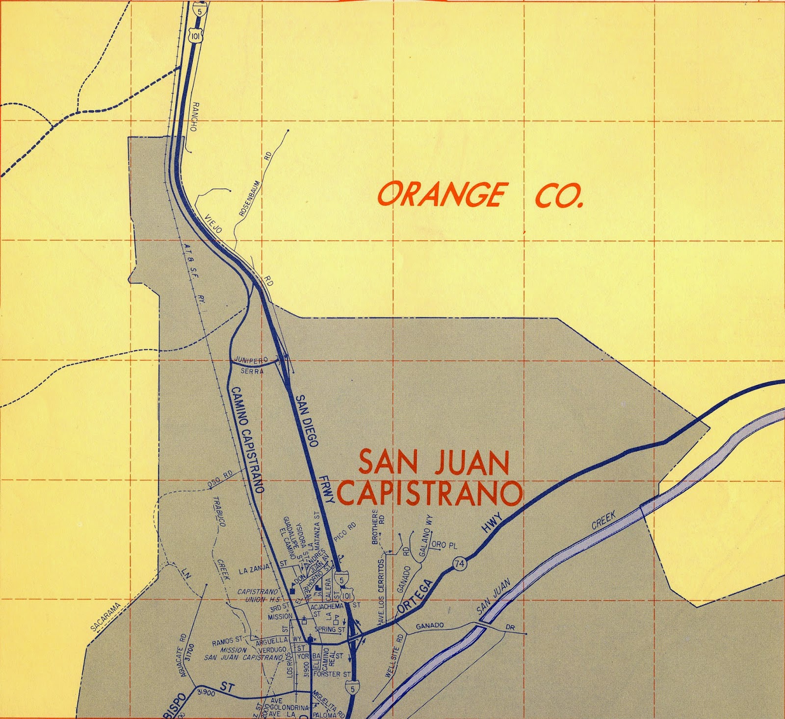
     Above is a topographic map, likely created in the mid-sixties (since it depicts the San Diego Fwy, the local stretch of which was finished in 1968), of the area along the freeway from San Juan Capistrano in the south to Saddleback College as it exists today. I've added a few streets (including Avery and Marguerite) that were created since then—plus, of course, the college itself (I used Saddleback's official campus map—it is to scale). Essentially, it's still an old map (my updating additions are pretty obvious), and so it provides a sense of how things once were—at right about the time that our district was conceived. [UPDATE: a local geologist informs me that the map was produced in 1968.]
     Naturally, I had topo data from the land that became Irvine Valley College, too, but its pretty uninteresting—the land is "as flat as Toby's ass," to use one of my dad's old expressions. (I'm afraid to ask who Toby is supposed to be.)

DETAIL: the road at the right/bottom is part of Ladera Ranch, which, natch
was created long after this map was made.
Click on graphic to ENLARGE
DETAIL: the green road (just under Trabuco Ck. Rd.) was called Rosenbaum Rd. 50 or 60 years ago. My father remembers that the Rosenbaum family had a major ranch in the old days: orange orchards. Evidently, they were still involved in disputes over water rights in the 70s.

Saturday, December 27, 2014

Maps: 1963 and today

     Today, my father informed me that he had a 1963 OC Thomas Guide, so I had him dig it out.
     Mostly, I'm consulting these old maps as a source for my efforts documenting and describing my family's history, but I made a point, today, of also scanning the zones in which our district's two colleges later appeared (in 1968* and 1979).
     Here's Google's current image/map of the area surrounding Irvine Valley College:

Click on graphics to ENLARGE
     The college is essentially that tan patch slightly below the center of the graphic. (I've indicated Culver Drive in green [at left] and Laguna Canyon Rd. in yellow [at right].)


     In this map from the 1963 Thomas Guide, IVC's future location is marked by my red X—on the corner of Valencia (later "Irvine Center Drive") and Jeffrey. Nearby Sand Canyon is called "Central" Ave., and the San Diego Fwy is described as "proposed."
     As I've explained previously, I've been told that the originally proposed site of this college (Saddleback College, north campus—it wasn't called IVC until 1985) was on Jamboree—the location of today's Tustin Market Place. But the Irvine Company provided "free" land on Jeffrey, and so the location was changed. (The city of Tustin is still peeved that "Irvine stole its college"! That's the story, anyway.)


     Here's a contemporary map of the region including Saddleback College (top) and San Juan Capistrano to the south (at the 74—the Ortega Highway). The red line in the middle is the location of Rosenbaum Rd., which exists today and existed also in 1963.


     And here we see most of the same area as of 1963 (I'm afraid I cut too much off the top—I'll correct that later.) Note the location of Rosenbaum Rd.
     The future location of Saddleback College is at the very top of the image, just east of the 5.

*Actually, the original site of the college, when it opened in Sept of 1968, was (temporarily) at 26522 Crown Valley Parkway, a half mile to the north. The temporary structures that contained the college in those days were moved to the current site, along Avery, a year or so later. See image below:

The red dot indicates SC's original location. Its ultimate
location is the complex at the bottom of the graphic.

Roy's obituary in LA Times and Register: "we were lucky to have you while we did"

  This ran in the Sunday December 24, 2023 edition of the Los Angeles Times and the Orange County Register : July 14, 1955 - November 20, 2...