Monday, December 29, 2014

Saddleback College: topographic map

Click on graphic to enlarge it
     My father, Gunther "Manny" Bauer, was appointed to the Santa Ana Mountains County Water District board in about 1978. He served on the board until the end of 1996. (The agency changed its name to the Trabuco Canyon Water District in the late 80s.)
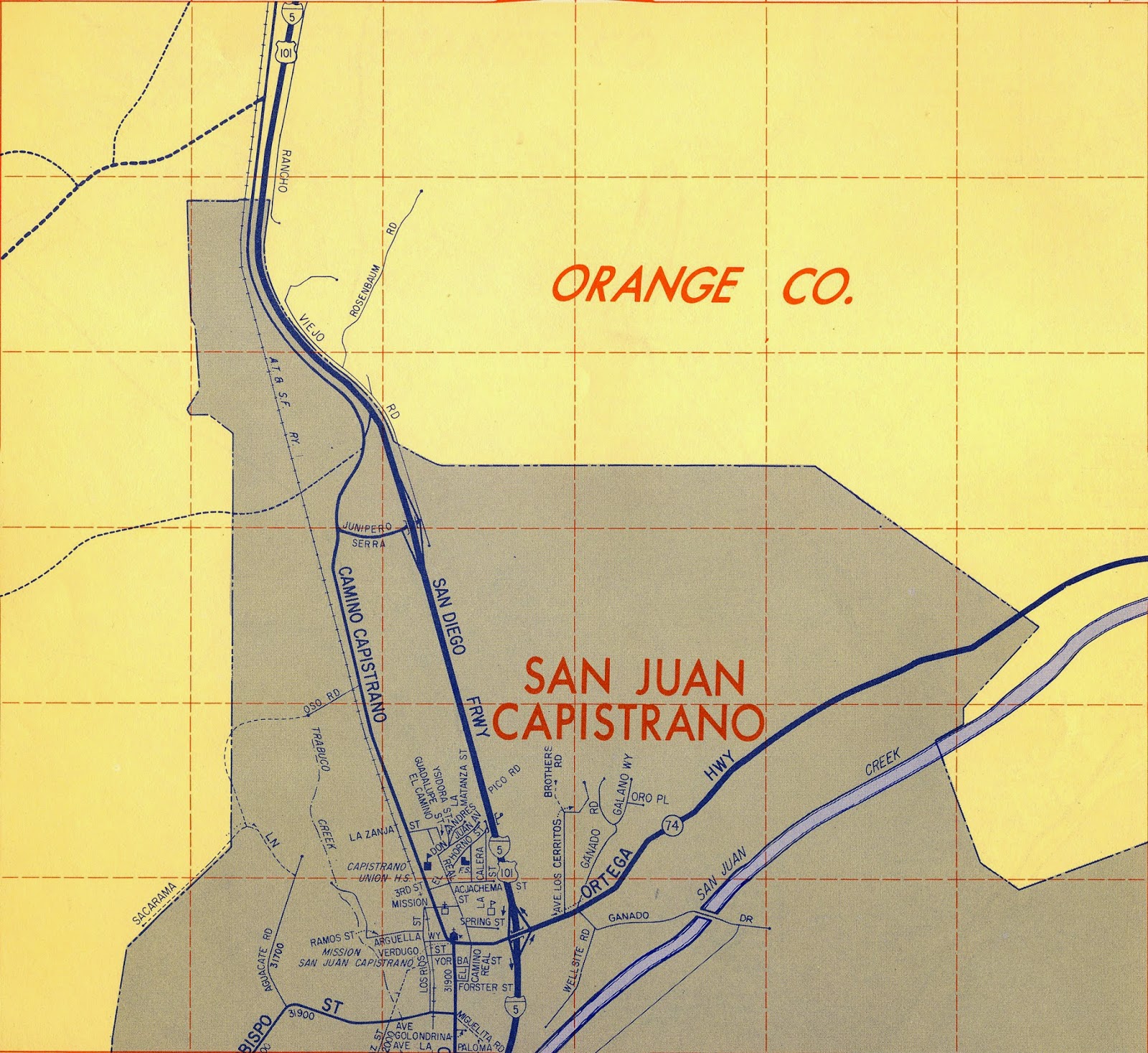
     Yesterday, Manny noted that he had a cache of cool old maps that he seems to have acquired during his time with the water district. I asked him to locate the maps. Today, I got a good look at 'em. (SEE.)
     Though the maps are part of a 1973 state report (including information about topography, minerals, earthquake faults, and land slides), much of the data they present is from much older data-gathering efforts, some going back to the 20s, some from the 60s or even later (the authors used the best data available to them, some of it old).
     Above is a topographic map, likely created in the mid-sixties (since it depicts the San Diego Fwy, the local stretch of which was finished in 1968), of the area along the freeway from San Juan Capistrano in the south to Saddleback College as it exists today. I've added a few streets (including Avery and Marguerite) that were created since then—plus, of course, the college itself (I used Saddleback's official campus map—it is to scale). Essentially, it's still an old map (my updating additions are pretty obvious), and so it provides a sense of how things once were—at right about the time that our district was conceived. [UPDATE: a local geologist informs me that the map was produced in 1968.]
     Naturally, I had topo data from the land that became Irvine Valley College, too, but its pretty uninteresting—the land is "as flat as Toby's ass," to use one of my dad's old expressions. (I'm afraid to ask who Toby is supposed to be.)

DETAIL: the road at the right/bottom is part of Ladera Ranch, which, natch
was created long after this map was made.
Click on graphic to ENLARGE
DETAIL: the green road (just under Trabuco Ck. Rd.) was called Rosenbaum Rd. 50 or 60 years ago. My father remembers that the Rosenbaum family had a major ranch in the old days: orange orchards. Evidently, they were still involved in disputes over water rights in the 70s.

Saturday, December 27, 2014

Maps: 1963 and today

     Today, my father informed me that he had a 1963 OC Thomas Guide, so I had him dig it out.
     Mostly, I'm consulting these old maps as a source for my efforts documenting and describing my family's history, but I made a point, today, of also scanning the zones in which our district's two colleges later appeared (in 1968* and 1979).
     Here's Google's current image/map of the area surrounding Irvine Valley College:

Click on graphics to ENLARGE
     The college is essentially that tan patch slightly below the center of the graphic. (I've indicated Culver Drive in green [at left] and Laguna Canyon Rd. in yellow [at right].)


     In this map from the 1963 Thomas Guide, IVC's future location is marked by my red X—on the corner of Valencia (later "Irvine Center Drive") and Jeffrey. Nearby Sand Canyon is called "Central" Ave., and the San Diego Fwy is described as "proposed."
     As I've explained previously, I've been told that the originally proposed site of this college (Saddleback College, north campus—it wasn't called IVC until 1985) was on Jamboree—the location of today's Tustin Market Place. But the Irvine Company provided "free" land on Jeffrey, and so the location was changed. (The city of Tustin is still peeved that "Irvine stole its college"! That's the story, anyway.)


     Here's a contemporary map of the region including Saddleback College (top) and San Juan Capistrano to the south (at the 74—the Ortega Highway). The red line in the middle is the location of Rosenbaum Rd., which exists today and existed also in 1963.


     And here we see most of the same area as of 1963 (I'm afraid I cut too much off the top—I'll correct that later.) Note the location of Rosenbaum Rd.
     The future location of Saddleback College is at the very top of the image, just east of the 5.

*Actually, the original site of the college, when it opened in Sept of 1968, was (temporarily) at 26522 Crown Valley Parkway, a half mile to the north. The temporary structures that contained the college in those days were moved to the current site, along Avery, a year or so later. See image below:

The red dot indicates SC's original location. Its ultimate
location is the complex at the bottom of the graphic.

Saturday, December 20, 2014

Teddy tonight

 Teddy was visiting my folks' place.
He found his favorite chair and sat in it.
He played games with my mom. He chased around a bit.

A big yawn from the most popular creature in the canyon.
Teddy Bauer, Superstar

Baby please come home

Thursday, December 18, 2014

Cookie Mas w/ Cuban cigars

     Yesterday, Rebel Girl and King David put on their annual “Cookie Mas” event, a delightfully loose and informal all-day party, featuring cookies (some baked by David’s mom, others baked by humanistic epicureans and dastardly feminists), cider, cheese 'n' crackers, and much mas. Cookie Mas—or "Cookiemas"—is vaguely Christmassy (some red and green cookies, natch), seriously informal (clothing optional), and way fun (Cuban cigars all around). It is always held, of course, in that ridiculous locus of the rotting wing of A200—known laughingly as the “faculty lounge,” a set of couches and chairs and patience-testing HP equipment. (Our “faculty lounge” used to feature a noisemaking Scantron machine, too, but a clever colleague banished that Flintstonian device to the nearby, soul-sucking duplicating/mail fortress.)

     All manner of persons dropped by throughout the day, including colleagues of other Schools—other, that is, than Humanities & Life Sciences, for the Reb and King D are members of those estimable units—administrators, classified employees (who seemed particularly happy to be there), students, and even one or two varmints, though no maggoty rats or mold spores.

The Reb was, again, intermittent host & cheerleader
     “Where,” asked some visitors, “was the scene of the notorious maggoty rat?” I showed ‘em. “It’s gone now, seriously gone now,” I insisted, sensing an unsavory clash between cookie and maggot. Jeannie insisted on telling the whole story, including mention of "300 writhing maggots on the carpet."

     At one point, the Reb declared that this would be the "last Cookie Mas ever to be held in A200," a factoid that immediately inspired tears and "ahhhhs." Feeling sentimental, I pondered: Can an event really be a Humanities event, if it does not occur in a lurid corner of a rotting and molding building?

     Yes!

     I do believe that yesterday’s Cookie Mas, the best Mas ever, achieved a fevered pitch at about noon yesterday. I was in my office preparing and grading exams, but I could hear the laughing and joking and Twister-playing in the background, a pleasant din. Someone yelped. Laughter. Swoonage. "Just like old times," I said.

     I will be insisting that the Reb and King D claim Flex Credit for this event, which exceeded virtually all other college events, official or otherwise, in camaraderie and funitude.

King D resides in the weird end of campus

Tell all the relatives: this is how we drive to work in So Cal

Roy's obituary in LA Times and Register: "we were lucky to have you while we did"

  This ran in the Sunday December 24, 2023 edition of the Los Angeles Times and the Orange County Register : July 14, 1955 - November 20, 2...